
Weather For the Week
It will be a rainy week as a warm front fires off Wednesday, bringing tropical moisture and 60-degree temperatures on Wednesday before turning colder on Thursday at 48. Temps rise back to 52 by Friday before dropping once more as another system crosses over; this system may bring snowfall, albeit very little and slushy. Next week looks like this week with 50s and 60s and rain.
Weather Story of the Week
As we exit winter, it’s time to review Severe Weather awareness. While severe weather usually happens in the summer months, that doesn’t mean it can’t happen in spring. Conway, MA had a tornado in 2017 on February 25. It doesn’t have to be summertime, it just needs to be warm enough (as well as other factors). If a severe thunderstorm warning is issued, it is advised to stay away from windows and stay indoors. This is due to lightning, hail/wind damage, and possible tornadoes.
If a Tornado Warning is issued, Take Cover Immediately! A tornado may be close to or on the ground. A PDS (Particularly Dangerous Situation) Tornado Warning (or severe thunderstorm warning) means that considerable damage is likely ongoing. A Tornado Emergency is the highest warning for upper-echelon tornadoes that are approaching a populated area. These tornadoes may be strong enough to a point where being underground is the only option. Severe warnings for PDS are usually winds exceeding 70 mph or hail over 1.25 inches.
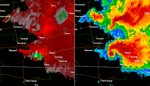
Another tip: If you look on the radar and see what looks like a hook on the radar blobs, that’s a common way to spot a tornado developing. Another way to spot a tornado is by looking at a wind velocity radar. In this example (see the picture accompanying this story), you can see two types of radar that existed in this storm. If you have a keen eye, you can see this is the tornado from 2011. This is the radar return at the peak of the Springfield tornado from the radar in Taunton, MA. On the left is velocity. On the right is reflectivity. Velocity is easy to remember. Green is inflow, wind heading towards the radar, red is outflow, away from the radar. If they meet, especially if it’s a strong couplet, that usually means a tornado is or close to touching down.
On reflectivity (right), there can be confusion. The northern cell has a line of pink, indicating very heavy rainfall or usually hail. But the tornadic southern cell is confusing to some. The pink before the hook is hail but the pink in the hook is debris. A ‘debris ball’ is evident that a tornado is on the ground and tossing debris to a point that radar is getting a return. How radar works is that radar fires a beam in every direction.
It goes until it runs out of energy, it hits an environmental structure (like a mountain) or it hits a storm. If it detects something within a storm, like debris or hail, a pink (if a ton of debris, it has been known to be purple to black) spot will show up. Not every tornado can be seen on radar, which is why it is important to have trained weather spotters relay information to the National Weather Service.
There are many other types of radar to detect rotating storms but I will do them another week. Remember to be aware during storms. When thunder roars, stay indoors!