
Sam’s Weather Report
May 16, 2023
Weather of the Week
A somewhat colder week, but still springtime warmth. Tuesday is looking to be the only 80-degree day this week. The rest of the week will be cooler, with highs in the upper 60s to low 70s. The next signal for rain is this weekend, on Sunday.
What’s going on in the Weather World?
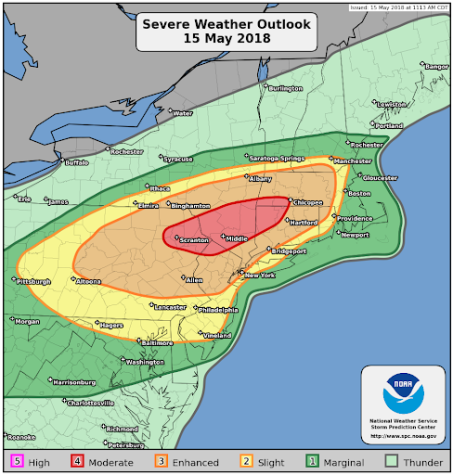
Monday marked five years since May 15, 2018, Derecho in New England and New York. A derecho is a line of thunderstorms with winds over 60 mph that continues in procession for at least 100 miles. On May 15th, the Storm Prediction Center issued a ‘Moderate Risk’ of Severe Weather. This means severe weather is certain to happen and some of it could be intense. The map below shows where the moderate risk was placed over.
At 2:30 pm EDT, National Weather Service radar was tracking a line that was becoming intense over portions of Eastern NY. Around 2:45 pm, storm chasers were reporting hail up to baseball size. In Saugerties, NY, an EF1 tornado, with winds up to 110 mph struck. In Kent, NY, an EF2 with winds of 115 mph caused some destruction, but no casualties. As the storms raced into CT and MA, they maintained their strength despite going over the Berkshires and Litchfield Co., CT hills. Tornado Warnings were being issued along the MA/CT border. From 3:45 to 4:00 pm, two tornadoes would touch down in CT. Along with tornadoes, damaging winds, and hail, torrential rainfall exceeded 3 inches in some spots. Dangerous cloud-to-ground lightning was present.
At the end of the event, there were no casualties. But it was carved into Northeast weather history.