
Weather for the Week
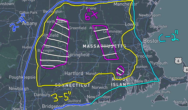
This week’s forecast consists of cold temperatures and multiple storms coming through our region. Thursday is currently looking like a snow day (in my opinion, hopefully), as a storm tracks over Southern New England in the morning. As of writing, this storm starts around 6-8 am Thursday as a snowstorm but as temperatures rise into the upper 30s, it becomes a rain-snow mix, which is extremely dangerous to travel through especially as this begins at 18z (2 pm ET), which would be the end of school. Personally, and speaking with safety in mind, I believe most schools in New England will close on Thursday due to the hazardous road conditions set forward. In terms of snow, we could be seeing as little as an inch to at most half a foot (6”). The real main concern is the ice, which, although I have no power in deciding this, I hope that the district is open to potentially just giving us a snow day or even a half day.
What’s Going on in the Weather World?
An interesting article from the American Meteorological Society came out just this past weekend highlighting a tweak in the way we rate tornadoes. Currently, we use the Enhanced Fujita (EF) scale, which is based on damage done by a tornado. There is a new scale in the works, though it’s unknown to me if NOAA will integrate it into their surveys. The EF scale measures tornadoes from the weakest EF0 with winds up to 85 mph to the strongest EF5 with some tornadoes like the 1999 Bridge Creek-Moore, OK tornado exceeding 318 mph. For this article, meteorologists and atmospheric scientists discuss lowering the requirement of EF5 from 201+mph to 190 mph. This marks an interesting case for tornadoes that have happened previously where the National Weather Service has indicated that the tornado could have been EF5 but the damage wasn’t consistent. This lowering of the requirement would settle major debates of tornadoes like the Mayflower-Vilonia, AR EF4 of April 27, 2014, which was rated a high-end EF4 with winds up to 190 mph, which has been debated due to the amount of evidence of neighborhoods obliterated by this tornado. Or the tornado back on March 24, 2023, in Rolling Fork, MS, which was rated EF4 with winds up to 195 mph. NWS Jackson, MS did note that the tornado was considered for EF5 strength but was lowered to EF4 because of a building failure in NE Rolling Fork. Whether or not anything happens, the rating doesn’t matter. What matters is the devastation and the recovery after these wraths of nature tear through.