Weather for the Week:
The end of the week looks mild and dry, with highs in the mid-30s. Thursday night into Friday morning could see a spot snow shower or two. However, as we approach the weekend, it appears to be a rollercoaster of weather. Saturday looks warm, with highs in the mid-40s, with rain in the evening. Sunday is cooler with highs in the upper 30s. A cold front approaches from the southwest, currently predicted models of a potential snowstorm on Sunday night into Monday. MLK day is very cold, only reaching the mid-20s for highs. Tuesday and Wednesday are not much better, with highs below 20 degrees.
What’s Going on in the Weather World?
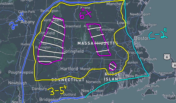
Currently, the snow totals for the aforementioned snowstorm look to be from a trace to 10 inches. That is a wild and problematic range for a snowstorm 4 days out. Currently, the image posted with this article is where I think the most amount of snow will be. Please note that this is both unofficial and preliminary, even 4 days out there can be major changes; even 24 hours out, it can be difficult to pinpoint. Just by purely looking at weather models and snow amounts, personally, this looks like a more south and west snowstorm than usual. What I mean is Boston could see 2” but Hartford could see 6”. Again, it is way too early to pinpoint how close this storm will pass by the coast. Areas of uncertainty are marked with white stripes, which would be in the hills of Worcester County, the Berkshire Mountains, and northern Rhode Island. In the valley here, I could see at max 6” from this storm, but otherwise, it’s up in the air, we really won’t know until it happens.


